By Robert "Bob" Bussey
This month’s story about the Mesa de Anguila will conclude the backpacking trip that Bob Bussey and two of his friends took during the month of April some years ago. While in most parts of the country April is a time of moderate temperature, that is not
necessarily so on the Mesa.
Bob Bussey lives in CenLa. Before moving here he lived in the Austin, Texas area where he was deeply involved in wilderness activities. He worked for the Austin Natural Science Center where he led backpacking, canoeing, kayaking, rock climbing and spelunking trips. He also worked for REC sports a division of the University of Texas where he led similar activities throughout Mexico and the United States. He also was a leader in an organization called Outback Expeditions. Later he became a bicycle tour leader for American Youth Hostels, leading six week bicycle camping trips, completely self-contained, throughout the United States. He later obtained his master’s degree in Outdoor Education from the University of Northern Illinois. He now lives in CenLa where he is still active in outdoor activities. If you would like to learn more about the Mesa de Anguila, he can be reached at Rlbussey450@icloud.com.
…
Backpackers to the Mesa de Anguila have more than the heat, lack of water and a multitude of trails to deal with during their hike. They also have the cacti to contend with while hiking on or off the trails. The most common cacti to be found on the mesa is Agave Lechuguilla. Each blade of the plant has a needle-like spine at its tip. These plants blanket the limestone slopes. Hikers either must spend time working their way through the labyrinth of plants or suffer the pain involved with trying to walk over one. Long pants and a good pair of leather hiking boots are a must when dealing with Lechuguilla.
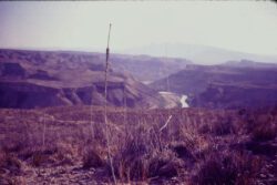
Lechuguilla, although it is often a pain to the hiker, has its beneficial uses. Deer browse on the bloom stalks, hearts, and tender young blades of the plant. In Mexico, the fiber from the plant is used to make coarse twine, rope, brushes, and other items. Natives in the Big Bend area were known to make a shampoo from the juices of the plant’s heart. And, in a round-about way, the plant can also aid the backpacker. Once during its lifetime, the plant sends up a tall bloom stalk. This stalk is quite straight, thick, and strong once it has died and dried out. Backpackers can use the dead bloom stalks as excellent walking sticks. They give the backpacker an extra means of balance while negotiating the twists and turns of the living cacti, are light to carry, and make a good support for your backpack when you take it off.
Ocotillo (a cactus that looks like an upside-down octopus with spines instead of suckers), pitaya (or strawberry cactus), prickly pear, and tasajillo (or pencil cactus) are the other common varieties of cacti present on the mesa. Each of these pose a potential hazard to the hiker.
The pencil cactus, tasajillo, can be especially tricky. A spine from this cactus will easily penetrate a person’s skin to a depth of one inch. Then, when you try to pull the spine out, it leaves behind a sheath or breaks off since the spine is retrorsely barbed. This usually gives the victim a nasty little infection or at least leaves a wound that takes a week or longer to heal.
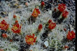
It has always seemed ironic to me that such wicked looking plants can be so beautiful when they bloom. The flowers and the spines of each cactus present an extreme contrast. In the harsh conditions of the desert, the plants need extra protection to live long enough to have a chance to be beautiful. Everyone on earth should have the opportunity to see the desert when the cacti are in full bloom: the colors are almost iridescent.
As we wound our way towards Tinaja Blanca in the heat of the day, our pace began to slow. The vistas and the plants may have been beautiful, but the ever-present heat would not let us forget that it was surrounding us. By early afternoon, it was obvious that we would have to find extra water. There are a number of ways to find springs or tinajas in the desert. Many animal trails lead directly to water sources. If you watch the birds long enough, especially the doves, they will also help point in the direction to water.
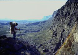
While on the mesa, we kept our eyes open for any potential tinaja locations. The washes that one finds on the mesa are the most likely spots to find waterholes. We found washes going down, which became side canyons to Santa Elana Canyon; others were found coming out of Broken back Mountain and other mountains on the mesa. One of the easiest ways we used to find water was to walk along the edge of a side canyon until we sighted a waterhole. Many times when we finally sighted a tinaja, it was located deep within one of the side canyons in a location where not too many four-footed animals could get to it. Tinajas that are easily accessible are rapidly drained by the wild animals unless they are deep tinajas. To get the water out of the tinajas that we found deep within the side canyons, we used a rope hauling system. While two of us climbed down the narrow side canyon, the third person waited on top, overlooking the tinaja. Water jugs were lowered on a climbing rope, filled, and then hauled back to the top. We found this to be the easiest, quickest, and safest method for retrieving water from the flash flood prone canyons.
After refilling our water jugs, we decided to spend the remainder of the hot afternoon in the shade of a narrow split in a rock wall. The desert sun was taking too much out of us: it was time for a siesta. The rock walls of the split were cool to the touch, and we were able to avoid the overhead sun by sitting on one side of the split or the other. This first day’s siesta proved to be relaxing and renewing for both our minds and bodies. From then on, during this trip, we lounged in some shade during the hot afternoon hours.
Travelling during the early morning hours and the late afternoon hours (when the sun was cooler) became our routine. Using this technique, we were able to hike for 6-8 hours every day. This also gave our bodies more time to acclimate to the heat. Our water intake continued to be high due to the amount of cooling our bodies were doing, but the mental fatigue that accompanies hiking in 95 to 105 degree heat had declined.
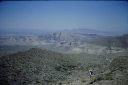
Our last day on the Mesa de Anguila saw us standing on the edge of the Terlingua Fault Line. This fault runs along the eastern side of the mesa. The mesa rests on the upthrown side of the dormant fault with the down thrown side being the desert floor to the east.
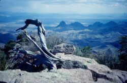
Looking east, from our vantage point, we could see the Chisos Mountains stretching from north to south across the desert floor. The Chisos range is the central mountain range in the park, reaching an elevation of 7,800 feet, and it harbors a sub-alpine environment. Most people who visit Big Bend end up in the Chisos because the temperatures there are so much cooler than in the rest of the park.
To descend from the mesa on its eastern side, one has two choices: either travel to its northeastern corner for an easy walk down or work one’s way down some steep slopes and then down an approximately 150-foot wall. Since our destination, Terlingua Abaja, was due east of our location, we decided to make two short rappels down the steep side of the mesa. The rappels–one anchored to a boulder and the other anchored to a mesquite bush growing in a crack of the limestone cliff–proved fairly easy.
Balancing our water ladened, top heavy packs was a minor difficulty. Trying to keep the climbing rope out of the cacti growing on the limestone wall was of greater concern. It is ticklish work running a cacti spine embedded rope through one’s hands while
rappelling. The first person to descend the rope had to stop periodically to remove spines from the rope. This person also tried to keep the rope from going back into the cacti.
After descending from the Mesa de Anguila, we quickly made our way towards Terlingua Creek for a soothing bath. Luckily, the creek contained enough water for us to fully submerge ourselves. With the water lazily rolling by, layers upon layers of salt and grim slowly came off our bodies. I’ve often thought that the next best thing to being out in the wilderness is the bath one takes after the outing. At that time a person rediscovers the true definition of the word “clean.”
Our trek at that point was essentially complete. From Terlingua Creek we merely had to walk a short distance to Terlingua Abaja (the location of our parked car). We were feeling elated over our trip across the Mesa de Anguila. We had been to an area that few backpackers attempt to cross or even know about. We successfully dealt with the heat and water problems. And, to our pleasure, we viewed a desert wilderness and found beauty.
Mesa de Anguila is not to be played with. It is true wilderness close to CENLA, and like most wilderness areas can be very uncompromising. Communication is almost nonexistent. Roads do not exist there. Traveling across it is normally on foot, whether two or four legged. We hope that it stays pristine and that motorized vehicles are never allowed on it. We hope you enjoyed these two articles.


